


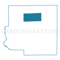
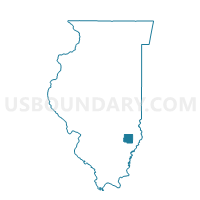
PRESTON 1 Voting District, Richland County, Illinois
About
Outline

Summary
| Unique Area Identifier | 574085 |
| Name | PRESTON 1 Voting District |
| County | Richland County |
| State | Illinois |
| Area (square miles) | 20.54 |
| Land Area (square miles) | 19.78 |
| Water Area (square miles) | 0.76 |
| % of Land Area | 96.30 |
| % of Water Area | 3.70 |
| Latitude of the Internal Point | 38.77699160 |
| Longtitude of the Internal Point | -88.09009250 |
Maps

Graphs
Select a template below for downloading or customizing gragh for PRESTON 1 Voting District, Richland County, Illinois


Neighbors
Neighoring Voting District (by Name) Neighboring Voting District on the Map
- CLAREMONT Voting District, Richland County, IL
- DENVER Voting District, Richland County, IL
- GERMAN Voting District, Richland County, IL
- NOBLE 2 Voting District, Richland County, IL
- OLNEY 11 Voting District, Richland County, IL
- OLNEY 5 Voting District, Richland County, IL
- OLNEY 7 Voting District, Richland County, IL
- OLNEY 9 Voting District, Richland County, IL
- PRESTON 2 Voting District, Richland County, IL
Top 10 Neighboring County Subdivision (by Population) Neighboring County Subdivision on the Map
- Olney township, Richland County, IL (10,334)
- Noble township, Richland County, IL (1,430)
- Preston township, Richland County, IL (1,247)
- Claremont township, Richland County, IL (855)
- Denver township, Richland County, IL (411)
- German township, Richland County, IL (341)
Top 10 Neighboring Unified School District (by Population) Neighboring Unified School District on the Map
- East Richland Community Unit School District 1, IL (14,052)
- West Richland Community Unit School District 2, IL (2,250)